My Blog List

Monday, April 30, 2012

TOP OF THE WORLD: NATO Rehearses For War In The Arctic


TOP OF THE WORLD: NATO Rehearses For War In The Arctic
The Western campaign for global dominance has reached the top of the world.


Global Research, April 24, 2012


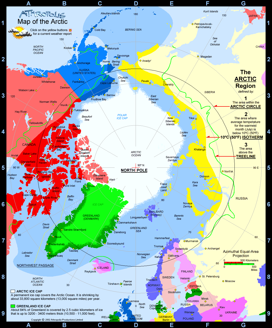
To the world’s military leaders, the debate over climate change is long over. They are preparing for a new kind of Cold War in the Arctic, anticipating that rising temperatures there will open up a treasure trove of resources and long-dreamed-of sea-lanes. Rick Rozoff scrutinizes the feverish military activity taking place in the High North, under the official label of a joint Norwegian-NATO-Partnership for Peace endeavor, including preparedness drills against terrorist threats, mass demonstrations...and spies coming in from the cold!

JPEG - 41.5 kb
Cold Response 2012 military exercise in Nordland, Norway. The yearly air land and maritime exercise is organized withing NATO with a UN mandate.

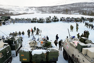
The largest military exercise in the High North, inside and immediately outside the Arctic Circle, since the end of the Cold War (and perhaps even before) was completed on March 21 in northern Norway.

Except for the crash of a Norwegian military transport plane in Sweden during its course the world would have been unaware of it.

Cold Response 2012 was conducted from March 12-21 primarily in Norway but also in Sweden with the participation of 16,300 troops from fifteen nations as part of full spectrum – air, sea, infantry and special forces – maneuvers against the backdrop of the past three years’ new scramble for the Arctic.

The term High North is a translation of the Norwegian designation nordområdene which was adopted by NATO in January of 2009 for its two-day Seminar on Security Prospects in the High North in Reykjavík, Iceland attended by the bloc’s secretary general, chairman of its Military Committee and two top military commanders, the Supreme Allied Commander Europe and the Supreme Allied Commander Transformation.

Four of the five Arctic claimants – the United States, Canada, Norway and Denmark – are members of NATO. The other, Russia, is not. In 2010 Norway became the first Arctic nation to move its military command center within the Arctic Circle, transferring the Norwegian Operational Command Headquarters from Stavanger to Bodø, a five-story complex built during the Cold War to withstand a nuclear attack. The preceding year Norway purchased 48 Lockheed Martin F-35 fifth generation multirole fighters.

Last month’s Cold Response was the largest of five such exercises held since 2006. The first was the largest military exercise ever conducted in Norway, with 10,000 troops from eleven nations. All NATO member states, at the time 26, were invited to participate.

The next, in 2007, included 8,500 military personnel. The third, in 2009, consisted of 7,000 troops from eleven nations and the fourth, in 2010, included 8,500 soldiers from fourteen nations.

This year’s Arctic drills were almost twice as large in terms of troop numbers as any preceding one.

Information on the exercise was scarce before, during and after the event; even the full roster of participating nations was not disclosed by the Norwegian military.

According to the website of the Norwegian Armed Forces, military forces from fifteen nations were involved – NATO members Norway, the U.S., Britain, France, Canada and the Netherlands – as well as Partnership for Peace affiliate Sweden, part of whose territory was employed for the exercise.

The other eight nations were not identified but the exercise was described as a joint Norwegian-NATO-Partnership for Peace undertaking. One of only a handful of English-language reports on the subject, from Finland, confirmed that nation’s participation. Finland and Sweden are for all intents the 29th and 30th members of the Alliance.

The other Partnership for Peace states involved are likely to have been, among others, former Soviet republics like Estonia, Latvia, Lithuania and Ukraine.

According to the Norwegian Armed Forces, “The main purpose of this year’s winter exercise is to rehearse high intensity operations in winter conditions within NATO with a UN mandate.”

The source added: “Participants will rehearse deploying and using military reaction forces in an area of crisis where they have to handle everything from high intensity warfare to terror threats and mass demonstrations. The soldiers have to balance the use of diplomatic and military force.”

High-intensity warfare, terror threats and mass demonstrations in the Arctic…

It also described live-fire infantry, naval and air – with the participation of fighter jets and helicopters operating from several Norwegian and Swedish bases and from aircraft carriers – components of the exercise.

The ground forces included U.S. Marines. According to the Marine Corps Times, “After years of fighting in a desert environment, most Marines may not think of the North Pole often, but the area abounds with oil, gas and other minerals, making it one of the most contentious regions of the world.”

The same source quoted a national security and Arctic expert at the Washington, D.C.-based Center for a New American Security with the improbable name of Will Rogers:

“The importance of why we need forces capable of operating in the Arctic is very basic power projection — to make a show to other players in the international community that we are an Arctic nation, and we are going to protect our interests in the Arctic Circle.”

Britain deployed HMS Illustrious, its last-remaining aircraft carrier, which had to return home early for repairs after being rammed by a tugboat, thereby eliciting a few paragraphs in the Daily Mail.

A Norwegian C-130 Super Hercules military transport plane crashed in Sweden, killing five soldiers. A memorial service was presided over by King Harald V, the titular commander-in-chief of the Norwegian armed forces.

The assault ship HMS Bulwark accompanied HMS Illustrious, which carried eight helicopters, and the first landed British commandos as well as American and Dutch troops, equipment and vehicles on the northern Norwegian coast.

In the words of the commanding officer of the Bulwark:

“It is not simply park the ship and offload it. In war – and therefore in training – we have to take account of the environment, enemy forces in the air, sea, and on land, coordinate people into boats and naval helicopters, all to arrive on target, in the right order, at the right time, to achieve the battle-winning effect. Few navies deliver this successfully and most aspirants look to the Royal Navy, Royal Marines, and Fleet Air Arm, with our war-proven capability, for guidance – on the sea in the air and on the land.”

Regarding “war-proven capability(ies),” Defense Media Network quoted U.S. Marine Corps Brigadier General James M. Lariviere, commanding general of 4th Marine Division, present for the occasion:

“It was an opportunity to interact with our allies. Many of them are veterans of Iraq, Afghanistan, and anti-piracy task forces off the coast of Somalia. They all have a lot of experience working with the U.S. and our allies in various capacities…”

The U.S. uses the Bjugn Cave Facility in Norway’s Fosen peninsula for Marine Corps Prepositioning Program Norway, the Marine Corps’ only land-based prepositioning program. According to a U.S. European Command article of last year:

“Well guarded within 671,000 sq. feet of six climate-controlled caves, $420 million worth of Marine Corps equipment and supplies lie ready for real world use. The caves, located in Norway, serve as a key strategic storage site for the Marine Corps….The Norwegian caves are strategically located to provide support to the United States Marine Corps’ operations around the globe…[T]he equipment from the climate controlled caves of Norway has seen action in places as diverse as the deserts of Iraq and mountains of Afghanistan in support of Operation Iraqi Freedom and Operation Enduring Freedom.”


The Helsingin Sanomat, which reported 215 Finnish soldiers participating in the exercise, characterized Cold Response 2012 as “a major military training exercise being held in the far north of Norway [in which] armed forces from 14 nations are protecting civilians in the same way as last year in Libya, and are fighting against the local opposition just as in Afghanistan.”

The newspaper also quoted a Finnish military media and communications officer stating, ”It would be silly to rehearse a situation if it were not realistic.”

A Swedish website, which identified Denmark, Spain, Estonia, Latvia and Switzerland as having also supplied units for Cold Response, published a synopsis of the scenario for the Swedish part of the exercise provided by the Swedish Armed Forces, which included:

A “strange group of people” have settled in northern Sweden and established a state called “Gardaland” from which they have invaded “an area in Norway,” after which NATO intervenes under a United Nations mandate.

The Ministry of Defence of the Netherlands reported a potpourri of unrelated and even conflicting scenarios that leaves the door open for any pretext for military intervention:

“The Netherlands Defence organisation sent 800 military personnel to take part in the exercise, including a large maritime detachment and units from the army and air force. The Dutch units left the Norwegian training area on 21 March, after a simulated attack lasting 48 hours. The emphasis was on beating off air attacks, combating submarines and covertly landing amphibious units. The scenario also included taking terrorists into custody.”

The Standing NATO Mine Countermeasures Group 1 was deployed to the Norwegian Arctic island city of Tromsø for the exercise. NATO established a Joint Warfare Centre in Stavanger, which at the time hosted the nation’s military command headquarters, in 2003. According to NATO’s Norfolk, Virginia-based Supreme Allied Command Transformation, the center is “the jewel in the Crown of Allied Command Transformation”.

On the opening day of this year’s Cold Response, Igor Korotchenko of Russia’s National Security Journal put the event in geopolitical perspective:

“The current military drill takes place amid NATO’s increased activities in the Arctic. Apparently, NATO is set on obtaining a share of Arctic resources and is carrying out the naval exercises to demonstrate that its geopolitical and diplomatic efforts lean on military might.”

Vladimir Yevseyev of the International Security Center of the Institute of Global Economy and International Relations, as cited by Voice of Russia, added:

“[T]he exercises are being held on the territories of Norway and Sweden, in close proximity to Russian borders. They might thus be seen as a provocation. Russia has all grounds for concern given that ships equipped with the…Aegis Combat System can be deployed in the Arctic.”

The last sentence is an allusion to the U.S.-NATO sea- and land-based interceptor missile system, which thus far is limited to Eastern Europe and the Mediterranean Sea but could well expand into the Norwegian, Barents, Baltic and Black Seas in future.

The Western campaign for global dominance has reached the top of the world.


Rick Rozoff is a frequent contributor to Global Research.

Saturday, April 21, 2012

Predator RQ-1 / MQ-1 / MQ-9 Reaper - - Airforce Technology

Predator RQ-1 / MQ-1 / MQ-9 Reaper - - Airforce Technology

Predator RQ-1 / MQ-1 / MQ-9 Reaper -, United States of America


RQ-1 Predator is a long-endurance, medium-altitude unmanned aircraft system for surveillance and reconnaissance missions. Surveillance imagery from synthetic aperture radar, video cameras and a forward-looking infrared (FLIR) can be distributed in real-time both to the front line soldier and to the operational commander, or worldwide in real-time via satellite communication links. MQ-1, armed with AGM-114 Hellfire missiles, is the multi-role version which is used for armed reconnaissance and interdiction.

A contract was awarded to General Atomics Aeronautical Systems in January 1994 to execute the Tier II, medium-altitude endurance Predator programme. The Predator system first flew in 1994 and entered production in August 1997.

Predators are currently in production for the US Air Force and are operational with the USAF 11th and 15th Reconnaissance Squadrons. Over 125 Predators have been delivered to the USAF. 36 additional MQ-1B Predators (with Hellfire missile installation kits) were ordered in September 2007. Six Predator UAVs are in service with the Italian Air Force. Italian company Meteor was responsible for assembly of five of the six. The Italian system was deployed to Iraq in January 2005.

"Predator is a long-endurance, medium-altitude unmanned aircraft system for surveillance and reconnaissance."

Predator UAVs have been operational in Bosnia since 1995 in support of Nato, UN and US operations and as part of Operation Enduring Freedom in Afghanistan and Operation Iraqi Freedom, flying over 500,000 flight hours on over 50,000 flights. The MQ-1 Predator achieved initial operating capability (IOC) in February 2005.

General Atomics is the prime contractor and the main subcontractors include: Versatron / Wescam for the electro-optical Skyball Gimbal; Northrop Grumman for the synthetic aperture radar; L3 Communication for the wideband satellite communications link; and Boeing for the intelligence workstation and mission planning system.

In February 2001, the Hellfire-C laser-guided missile was successfully fired from a Predator air vehicle in flight tests at Nellis air force base, Nevada. In November 2002 in Yemen, a Predator UAV was used to drop a Hellfire missile which destroyed a civilian vehicle carrying suspected terrorists. A Northrop Grumman Bat submunition was successfully dropped and a FINDER mini-UAV launched from a Predator UAV in August 2002.

MQ-9 Reaper Hunter / Killer

In May 1998 General Atomics was awarded a block 1 upgrade contract to expand the capabilities of the Predator system. System upgrades include development of an improved relief-on-station (ROS) system which allows continuous coverage over areas of interest without any loss of time on station, secure air traffic control voice relay, Ku-band satellite tuning and implementation of an air force mission support system (AFMSS).

The upgrade also covers a more powerful turbocharged engine and wing de-icing systems to enable year-round operations. The upgraded Predator, the Predator B, has been operational in the Balkans since April 2001. In March 2005, the USAF awarded a further contract for the system design and development (SDD) of MQ-9 Reaper Hunter / Killer. 21 MQ-9 have been ordered and eight delivered to the USAF.

The first USAF MQ-9 squadron, the 42nd Attack Squadron, was formed in March 2007. It is based at Creech AFB in Nevada. A decision on full-rate production of the MQ-9 is expected in 2009.

The USAF first deployed the MQ-9 Reaper to Afghanistan in October 2007, where it is being used for precision strikes. The MQ-9 Reaper flew its first operational mission in Iraq in July 2008.

The MQ-9 Reaper has an operational ceiling of 50,000ft, a maximum internal payload of 800lb and external payload over 3,000lb. It can carry up to four Hellfire II anti-armour missiles and two laser-guided bombs (GBU-12 or EGBU-12) and 500lb GBU-38 JDAM (joint direct attack munition). In May 2008, a USAF Reaper successfully test dropped four Raytheon GBU-49 Enhanced Paveway II 500lb bombs, which have laser and GPS guidance.

The MQ-9 sensor payload can include the General Atomics Lynx SAR (synthetic aperture radar). Lynx also features ground moving target indicator technology. The Predator is to be flight tested with a L-3 communications tactical common datalink (TCDL).

"The Predator B unmanned air vehicle has an operational ceiling of 50,000ft."

In August 2005, a version of Predator B, called Sky Warrior, was chosen for the four-year system development and demonstration (SDD) phase of the US Army's extended range / multi-purpose (ER/MP) UAV programme – 11 Sky Warrior systems, each with 12 air vehicles and five ground control stations.

Initial operating capability is planned for 2009. Two block 0 Sky Warrior UAVs were deployed to Iraq in April 2008.

Also in August 2005, the US Department of Homeland Security / Customs and Border Protection (DHS/CBP) ordered two Predator B systems for monitoring of the USA's south-west border. The first was delivered in late 2005, the second in September 2006. Two further systems were ordered in October 2006, for monitoring operations on the border with Canada.

In September 2006, the UK requested the foreign military sale (FMS) of two MQ-9 Reaper systems with Lynx SAR, multi-spectral targeting systems and one ground station. Deliveries began in mid-2007 and the RAF deployed the system in Afghanistan in November 2007. In January 2008, the UK requested the sale of an additional ten MQ-9 systems.

In August 2008, Italy requested the sale of four MQ-9 Reaper systems with three ground stations.

System components

A typical Predator system configuration would include four aircraft, one ground control system and one Trojan Spirit II data distribution terminal. The Predator air vehicle is 27ft in length and has a 49ft wingspan. The system operates at an altitude of 25,000ft and at a range of 400nm.

The endurance of the air vehicle is more than 40 hours and the cruise speed is over 70kt. The air vehicle is equipped with UHF and VHF radio relay links, a C-band line-of-sight data link which has a range of 150nm and UHF and Ku-band satellite data links.

Payload

The surveillance and reconnaissance payload capacity is 450lb and the vehicle carries electro-optical and infrared cameras and a synthetic aperture radar. The two-colour DLTV television is equipped with a variable zoom and 955mm Spotter. The high resolution FLIR has six fields of view, 19mm to 560mm.

The Raytheon multi-spectral targeting system (MTS-A) is fitted on the MQ-1/9 Predator. The MTS-A provides real-time imagery selectable between infrared and day TV as well as a laser designation capability. MQ-1 can employ two laser-guided Hellfire anti-armour missiles with the MTS.

The Northrop Grumman TESAR synthetic aperture radar is fitted on the MQ-1 and provides all-weather surveillance capability, has a resolution of 1ft. Other payload options, which can be selected to meet mission requirements, include a laser designator and rangefinder, electronic support and countermeasures and a moving target indicator (MTI).

The USAF plans to equip a number of MQ-1 and MQ-9 Predators with a version of the Northrop Grumman airborne signals intelligence payload (ASIP) from 2010. Northrop Grumman was awarded a contract for the development and flight testing of the system on an MQ-1 in April 2008. ASIP is being tested on the U-2 reconnaissance aircraft and will also be fitted on the RQ-4 Global Hawk.

Ground station

The UAV ground control station is built into a single 30ft trailer, containing pilot and payload operator consoles, three Boeing data exploitation and mission planning consoles and two synthetic aperture radar workstations together with satellite and line-of-sight ground data terminals.

"Predator is 27ft in length and has a 49ft wingspan."

The ground control station can send imagery data via a landline to the operational users or to the Trojan Spirit data distribution system which is equipped with a 5.5m dish for Ku-band ground data terminal and a 2.4m dish for data dissemination.

Operation

Predator follows a conventional launch sequence from a semi-prepared surface under direct line-of-sight control. The take-off and landing length is typically 2,000ft. The mission can be controlled through line-of-site data links or through Ku-band satellite links to produce continuous video.

Video signals received in the ground control station are passed to the Trojan Spirit van for worldwide intelligence distribution or directly to operational users via a commercial global broadcast system. Command users are able to task the payload operator in real-time for images or video on demand.


RQ-1A Predator is a long endurance, medium altitude unmanned aircraft system for surveillance and reconnaissance missions. It has a Ku-band satellite data link to provide over-the-horizon mission capabilities.
Predator UAVs have been operational in Bosnia since 1995, where they have flown over 600 missions for more than 4,000 hours in support of Nato, UN and US operations.
Predator operated from a tactical control station located aboard the USS Carl Vinson, Nimitz class aircraft carrier. The synthetic aperture radar (SAR) provides Predator with an all-weather, through-the-clouds surveillance capability.
The Predator medium-altitude long-endurance UAV. A typical Predator system configuration would include four aircraft, one ground control system and one Trojan Spirit II data distribution terminal.
Predator UAV carrying an Hellfire-C laser-guided missile.
Predator B is powered by a turboprop engine and can carry a greatly increased payload.
Predator B can conduct multiple missions simultaneously due to its large internal and external payload capacity.
Designated MQ-9 Hunter-Killer, Predator B's primary mission is interdiction and conducting armed reconnaissance against critical, perishable targets.


Related Projects

Arcturus T-20 Unmanned Aerial Vehicle
T-20 is a medium range tactical unmanned aerial vehicle (UAV) system...

Maveric Small Unmanned Aerial System
The Maveric is a mini unmanned aerial system (UAS) developed by...

Penguin B Unmanned Aerial Vehicle
Penguin B is a multirole small unmanned aerial vehicle designed...

DRDO Lakshya Unmanned Aerial Vehicle
Lakshya is a remotely piloted aerial vehicle designed and built...

RQ-170 Sentinel Unmanned Aerial Vehicle
The RQ-170 Sentinel is a high altitude and long endurance unmanned ...

See all projects

Sunday, April 15, 2012

HAARP Home Page

Go here to site.

Link: HAARP Home Page


HAARP and earthquakes « Heaven Awaits

HAARP and earthquakes « Heaven Awaits

HAARP and earthquakes

I have heard much speculation that HAARP caused the earthquake in China in May, 2008. Does the real science back this speculation?

This is the website for HAARP

http://www.haarp.alaska.edu/

This speculation seems to be unjustified.

Note:

There was a Chinese video of the sky before the May 2008 earthquake. I addressed this phenomenon on this post:

http://heavenawaits.wordpress.com/signs-in-the-sky-%E2%80%93-natural-or-unnatural-end-times/

-

-

Reasons:

(1) Earthquakes have happened before HAARP even existed.

Earthquakes have happened before in China, in 1927 (7.9), in 1932,(7.6), and 1976 (7.5), all before HAARP was established in 1990. So, just because another earthquake happened in China, does not mean it is correlated with HAARP. See history map below.

-

-

(2)The earth is shifting in plates. The earth may be affected by electromagnetic activity of the sun, or other artificial devices, but it has its own electromagnetic and mechanical activity as well.

The Schumann resonances (SR) are a set of spectrum peaks in the extremely low frequency (ELF) portion of the Earth’s electromagnetic field spectrum. Schumann resonances are global electromagnetic resonances, excited by lightning discharges in the cavity formed by the Earth surface and the ionosphere. Schumann resonance occurs because the space between the surface of the Earth and the conductive ionosphere acts as a waveguide.

Since the early days of radio, in the age of Nikolai Tesla,it has been known the earth has a natural electromagnetic resonance of its own. If you take your receiver and tune below the Schumann Resonance down to about 0.9 or 1 Hz you will hear static from yet another resonant source. This is the Alfven Resonance. there are primarily three schools of thought about the source of the Alfven Resonance. These are: (1) magnetospheric, (2) ionospheric and (3) lithospheric interactions with radio waves. The Alfven Resonance may not be due to radio waves in the air, but is actually coming from the earth due to random seismic activity around the planet.

-

-

The magnetosphere is there to protect the earth from the solar winds.

-

-

The lithosphere (geosphere) is the “solid” part of Earth. It has two parts, the crust and the upper mantle.The crust is Earth’s outermost layer. The crust varies from 5 to 70 kilometers in thickness. The crust includes rocks, minerals, and soil. There are two kinds of crust: continental and oceanic. Yes, there is even crust under the ocean!

The crust is constantly moving, which is why continents move and earthquakes happen. The science that studies how the parts of the crust move is called “Plate Tectonics.”

Earth’s oceanic crust is a thin layer of dense rock about 5 kilometers thick. The continental crust is less dense, with lighter-colored rock, that varies from 30 to 70 kilometers thick. The continental crust is older and thicker than the oceanic crust.

-

-

The ionosphere is the uppermost part of the atmosphere, distinguished because it is ionized by solar radiation. It plays an important part in atmospheric electricity and forms the inner edge of the magnetosphere. It has practical importance because, among other functions, it influences radio propagation to distant places on the Earth. It is located in the Thermosphere.

The lowest part of the Earth’s atmosphere is called the troposphere and it extends from the surface up to about 10 km (6 miles). The atmosphere above 10 km is called the stratosphere, followed by the mesosphere. It is in the stratosphere that incoming solar radiation creates the ozone layer. At heights of above 80 km (50 miles), in the thermosphere, the atmosphere is so thin that free electrons can exist for short periods of time before they are captured by a nearby positive ion. The number of these free electrons is sufficient to affect radio propagation. This portion of the atmosphere is ionizedand contains a plasma which is referred to as the ionosphere.

The ionization depends primarily on the Sun and its activity. Thus there is a diurnal (time of day) effect and a seasonal effect. The local winter hemisphere is tipped away from the Sun, thus there is less received solar radiation. The activity of the sun is associated with the sunspot cycle, with more radiation occurring with more sunspots. Radiation received also varies with geographical location (polar, auroral zones, mid-latitudes, and equatorial regions). There are also mechanisms that disturb the ionosphere and decrease the ionization. There are disturbances such as solar flares and the associated release of charged particles into the solar wind which reaches the Earth and interacts with its geomagnetic field.

-

-

(3) It has historically been more evident that earthquakes affected the ionosphere (area of HAARP activity) rather than the ionosphere affecting the earthquakes.

References:

(a) Ultra-low-frequency electromagnetic waves in the Earth’s crust and magnetosphere

A V Guglielmi 2007 Phys.-Usp. 50 1197-1216

Institute of Physics of the Earth, Russian Academy of Sciences, Moscow, Russian Federation

Abstract. Research on natural intra- and extra terrestrially produced electromagnetic waves with periods ranging from 0.2 to 600 s is reviewed. The way in which the energy of rock movements transforms into the energy of an alternating magnetic field is analyzed. Methods for detecting seismomagnetic signals against a strong background are described. In discussing the physics of ultra-low-frequency waves in the magnetosphere, the 11-year activity modulation of 1-Hz waves andponderomotive forces affecting plasma distribution are emphasized.

(b) The quaking ionosphere – earthquake disturbs ionosphere

Science News, Oct 19, 1985

On April 12, 1978, something strange happened to the ionosphere above Chatanika, Alaska. Scientists routinely monitoring the flow of ionospheric particles detected very large verticle oscillations corresponding at times to ion velocities of up to 100 meters per second. Normally, ionospheric winds travel almost exclusively in the horizontal direction. And any verticle motions –rarely larger than 2 m/sec — are usually associated with changes in the magnetic field, but no such variations were recorded that day.

The mystery was solved when Michael Kelley at Cornell University in Ithaca, N.Y., and Robert Livingston and Mary McCready at SRI International in Menlo Park, Calif., linked the nine-hour-long ionospheric disturbance to an earthquake that had occurred 1,000 kilometers from the radar site just before the oscillations began. As discussed in the September GEOPHYSICAL RESEARCH LETTERS, the researchers found that their data compared well with a theory developed 18 years ago, which predicts that a nuclear explosion or earthquake will excite atmospheric motion near the event much like that created when a pebble falls in water.

In order to fit the data to the model, however, they had to assume that the ionosphere was hotter than normal, suggesting that the earthquake had heated the upper atmosphere. According to Kelley, energy from earthquakes, tornadoes and weather in the lower atmosphere may play a much more important role in warming the upper atmosphere than has usually been assumed.

(c). GPS detection of total electron content variations over Indonesia and Thailand following the 26 December 2004 earthquake

We report the response of the ionosphere to the large earthquake that occurred in West Sumatra, Indonesia, at 0058 UT on December 26, 2004. We have analyzed Global Positioning System (GPS) data obtained at two sites in Sumatra and at three sites in Thailand to investigate total electron content (TEC) variations. Between 14 and 40 min after the earthquake, TEC enhancements of 1.6-6.9 TEC units (TECU) were observed at subionospheric points located 360-2000 km north of the epicenter. From the time delays of the observed TEC enhancements, we find that the TEC enhancements propagated northward from the epicenter. The time delays between the earthquake and rapid increases in TEC, which occurred near the epicenter, are consistent with the idea that acoustic waves generated by the earthquake propagated into the ionosphere at the speed of sound to cause the TEC variations. A small TEC enhancement of 0.6 TECU was observed south of the epicenter, while no TEC enhancements were seen east of the epicenter. From a model calculation, we find that this directivity of the TEC variations with respect to the azimuth from the epicenter could be caused partially by the directivity in the response of the electron density variation to the acoustic waves in the neutral atmosphere.

(d) Ionospheric post-seismic perturbations following the Tokachi-Oki earthquake from high rate GPS Japanese data : wave source and propagation Ionospheric perturbations

Crespon, F. (1,2) ; Occhipinti, G. (1); Garcia, R. (1);Lognonné, P. (1) and Murakami, M. (3)(1) Institutde Physique duGlobe de Paris, Départementde Géophysique Spatialeet Planétaire, 4 avenue de Neptune, 94107, St Maurdes Fossés, France (2) Noveltis, Parc Technologique duCanal, 2 rue de l’Europe, 31520, Ramonville, France(3) Geographical Survey Institute, Geography and CrustalDynamics Research Center, Kitasato-1, Tsukuba, 305-0811

Ionospheric perturbations following the Tokachi-Oki earthquake (East of Hokkaido island) have been sensed by the high rate continuous GPS Network of Japan. Thestrong motions have produced infrasonic waves propagating into the ionosphere and generating electronic density perturbations. The electronic content along GPS satellite to GPS receiver rays is extracted from the raw data. The attenuation of infrasonic waves by the atmosphere is demonstrated on these signals. Then, the GPS data have been inverted to reconstruct 3D tomographic images of the electronic density perturbations. The ionospheric waves far from the source are propagating horizontally at the speed of seismic surface waves and vertically at the speed of sound in the atmosphere. Close to the source, the signal has been analyzed and modeled in order to constraint the source location and the source mechanism. These studies demonstrate the interest of post-seismic ionospheric perturbations to retrieve the long period strong motions that are notable inland due to the saturation of seismometers, and in the ocean due to the low number of ocean bottom seismometers.

Conclusion:

I doubt that HAARP activity caused the China earthquake.It is more likely that the pre- and post- earthquake conditions affected the atmosphere, rather than the atmosphere affected the earthquake.